Overview
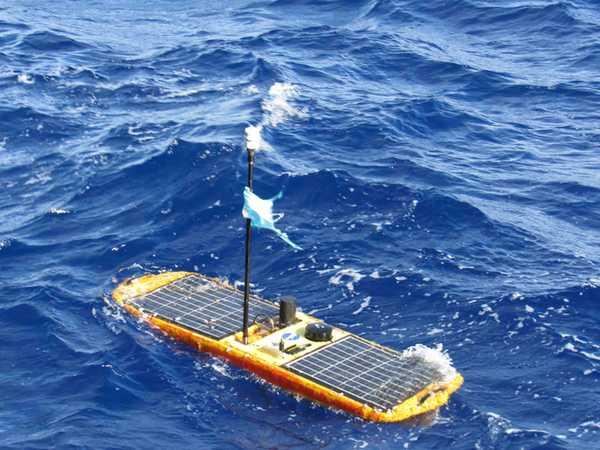
The Wave Glider is an autonomous, uncrewed surface vehicle (USV) developed by Liquid Robotics. Researchers can deploy the Wave Glider to investigate ocean environments that are often difficult to access with other equipment and personnel. Data can be collected continuously for up to 12 months without refueling, as the Wave Glider is powered by wave and solar energy.
Online information
Related Campaigns & Instruments
Review the instruments operated on this platform for each of these field campaigns
Slide 1 of 4

Sub-Mesoscale Ocean Dynamics Experiment
2021—2023
Centered approximately 300 km offshore of San Francisco, California, USA
view all deployment dates
3 Deployments
· 39 Data Products| 2023-04-03 | 2023-05-02 |
| 2022-10-06 | 2022-11-07 |
| 2021-10-17 | 2021-11-09 |
Conductivity, Temperature, and Depth (CTD) sensors are in situ instruments that measure water depth, pressure, salinity, temperature, and density in the ocean. CTD sensors can be deployed on various water-based platforms, including autonomous underwater vehicles (AUVs), buoys, gliders, and research vessels. When mounted on a vessel, CTD sensors are typically attached to a rosette and lowered to the seafloor to record water properties. These sensors typically sample at 30 Hz and can provide accurate measurements at specific water depths, tailored to the researcher's needs.
Earth Science > Oceans > Ocean Pressure > Water Pressure
Earth Science > Oceans > Bathymetry/seafloor Topography > Water Depth
Earth Science > Oceans > Salinity/density > Conductivity
Earth Science > Oceans > Salinity/density > Density
Earth Science > Oceans > Salinity/density > Salinity
Earth Science > Oceans > Ocean Temperature > Water Temperature
Earth Science > Oceans > Salinity/density
The Acoustic Doppler Current Profiler (ADCP) is an in situ acoustic sensor that measures ocean currents. It uses the Doppler effect to detect sound waves, providing measurements of current speed and direction throughout the water column. It can be easily mounted on various water platforms, such as ships, buoys, and autonomous underwater vehicles (AUVs). Additionally, it can be deployed on the seafloor to provide profile measurements of ocean currents.
Earth Science > Oceans > Ocean Acoustics
Earth Science > Oceans > Ocean Circulation > Ocean Currents
Generic-Atmospheric State (Gen-AtmsState) refers to non-specific instruments on a platform that measure atmospheric state parameters. These are typically in situ sensors that measure temperature, pressure, humidity, and wind speed and direction. Types of atmospheric state instruments include thermometers, hygrometers, barometers, and anemometers.
Earth Science > Atmosphere > Atmospheric Water Vapor
Earth Science > Atmosphere > Atmospheric Pressure
Earth Science > Atmosphere > Atmospheric Water Vapor > Water Vapor Indicators > Humidity
Earth Science > Atmosphere > Atmospheric Temperature > Surface Temperature > Air Temperature
Earth Science > Atmosphere > Atmospheric Winds > Upper Level Winds > Wind Direction
Earth Science > Atmosphere > Atmospheric Winds > Upper Level Winds > Wind Speed
Earth Science > Atmosphere > Atmospheric Pressure > Atmospheric Pressure Measurements
Earth Science > Atmosphere > Atmospheric Winds > Surface Winds > Wind Direction
Earth Science > Atmosphere > Atmospheric Temperature
Earth Science > Atmosphere > Atmospheric Winds > Surface Winds > Wind Speed
Earth Science > Atmosphere > Atmospheric Winds
Generic-Radiometers refer to non-specific radiometers on a platform. These are typically passive microwave radiometers that measure brightness temperature. Radiometers can be used to retrieve temperature and water vapor profiles, soil moisture content, ocean salinity, precipitation and cloud properties, and vegetation.
Earth Science > Spectral/engineering > Microwave > Brightness Temperature

Salinity and Stratification at the Sea Ice Edge
2022
Beaufort Sea
view all deployment dates
1 Deployment
· 19 Data Products| 2022-08-11 | 2022-10-05 |
Generic-Atmospheric State (Gen-AtmsState) refers to non-specific instruments on a platform that measure atmospheric state parameters. These are typically in situ sensors that measure temperature, pressure, humidity, and wind speed and direction. Types of atmospheric state instruments include thermometers, hygrometers, barometers, and anemometers.
Earth Science > Atmosphere > Atmospheric Water Vapor
Earth Science > Atmosphere > Atmospheric Pressure
Earth Science > Atmosphere > Atmospheric Water Vapor > Water Vapor Indicators > Humidity
Earth Science > Atmosphere > Atmospheric Temperature > Surface Temperature > Air Temperature
Earth Science > Atmosphere > Atmospheric Winds > Upper Level Winds > Wind Direction
Earth Science > Atmosphere > Atmospheric Winds > Upper Level Winds > Wind Speed
Earth Science > Atmosphere > Atmospheric Pressure > Atmospheric Pressure Measurements
Earth Science > Atmosphere > Atmospheric Winds > Surface Winds > Wind Direction
Earth Science > Atmosphere > Atmospheric Temperature
Earth Science > Atmosphere > Atmospheric Winds > Surface Winds > Wind Speed
Earth Science > Atmosphere > Atmospheric Winds
Conductivity, Temperature, and Depth (CTD) sensors are in situ instruments that measure water depth, pressure, salinity, temperature, and density in the ocean. CTD sensors can be deployed on various water-based platforms, including autonomous underwater vehicles (AUVs), buoys, gliders, and research vessels. When mounted on a vessel, CTD sensors are typically attached to a rosette and lowered to the seafloor to record water properties. These sensors typically sample at 30 Hz and can provide accurate measurements at specific water depths, tailored to the researcher's needs.
Earth Science > Oceans > Ocean Pressure > Water Pressure
Earth Science > Oceans > Bathymetry/seafloor Topography > Water Depth
Earth Science > Oceans > Salinity/density > Conductivity
Earth Science > Oceans > Salinity/density > Density
Earth Science > Oceans > Salinity/density > Salinity
Earth Science > Oceans > Ocean Temperature > Water Temperature
Earth Science > Oceans > Salinity/density
The Acoustic Doppler Current Profiler (ADCP) is an in situ acoustic sensor that measures ocean currents. It uses the Doppler effect to detect sound waves, providing measurements of current speed and direction throughout the water column. It can be easily mounted on various water platforms, such as ships, buoys, and autonomous underwater vehicles (AUVs). Additionally, it can be deployed on the seafloor to provide profile measurements of ocean currents.
Earth Science > Oceans > Ocean Acoustics
Earth Science > Oceans > Ocean Circulation > Ocean Currents
SPURS
Salinity Processes in the Upper Ocean Regional Study
2012—2017
Subtropical North Atlantic Ocean, Tropical Eastern Pacific Ocean
view all deployment dates
2 Deployments
· 41 Data Products| 2012-08-16 | 2013-10-13 |
| 2016-08-13 | 2017-11-17 |
Generic-Atmospheric State (Gen-AtmsState) refers to non-specific instruments on a platform that measure atmospheric state parameters. These are typically in situ sensors that measure temperature, pressure, humidity, and wind speed and direction. Types of atmospheric state instruments include thermometers, hygrometers, barometers, and anemometers.
Earth Science > Atmosphere > Atmospheric Water Vapor
Earth Science > Atmosphere > Atmospheric Pressure
Earth Science > Atmosphere > Atmospheric Water Vapor > Water Vapor Indicators > Humidity
Earth Science > Atmosphere > Atmospheric Temperature > Surface Temperature > Air Temperature
Earth Science > Atmosphere > Atmospheric Winds > Upper Level Winds > Wind Direction
Earth Science > Atmosphere > Atmospheric Winds > Upper Level Winds > Wind Speed
Earth Science > Atmosphere > Atmospheric Pressure > Atmospheric Pressure Measurements
Earth Science > Atmosphere > Atmospheric Winds > Surface Winds > Wind Direction
Earth Science > Atmosphere > Atmospheric Temperature
Earth Science > Atmosphere > Atmospheric Winds > Surface Winds > Wind Speed
Earth Science > Atmosphere > Atmospheric Winds
Conductivity, Temperature, and Depth (CTD) sensors are in situ instruments that measure water depth, pressure, salinity, temperature, and density in the ocean. CTD sensors can be deployed on various water-based platforms, including autonomous underwater vehicles (AUVs), buoys, gliders, and research vessels. When mounted on a vessel, CTD sensors are typically attached to a rosette and lowered to the seafloor to record water properties. These sensors typically sample at 30 Hz and can provide accurate measurements at specific water depths, tailored to the researcher's needs.
Earth Science > Oceans > Ocean Pressure > Water Pressure
Earth Science > Oceans > Bathymetry/seafloor Topography > Water Depth
Earth Science > Oceans > Salinity/density > Conductivity
Earth Science > Oceans > Salinity/density > Density
Earth Science > Oceans > Salinity/density > Salinity
Earth Science > Oceans > Ocean Temperature > Water Temperature
Earth Science > Oceans > Salinity/density
ATOMIC
Atlantic Tradewind Ocean-Atmosphere Mesoscale Interaction Campaign
2020
Tropical North Atlantic east of Barbados
view all deployment dates
1 Deployment
· 1 Data Product| 2020-01-07 | 2020-02-13 |
Generic-Atmospheric State (Gen-AtmsState) refers to non-specific instruments on a platform that measure atmospheric state parameters. These are typically in situ sensors that measure temperature, pressure, humidity, and wind speed and direction. Types of atmospheric state instruments include thermometers, hygrometers, barometers, and anemometers.
Earth Science > Atmosphere > Atmospheric Water Vapor
Earth Science > Atmosphere > Atmospheric Pressure
Earth Science > Atmosphere > Atmospheric Water Vapor > Water Vapor Indicators > Humidity
Earth Science > Atmosphere > Atmospheric Temperature > Surface Temperature > Air Temperature
Earth Science > Atmosphere > Atmospheric Winds > Upper Level Winds > Wind Direction
Earth Science > Atmosphere > Atmospheric Winds > Upper Level Winds > Wind Speed
Earth Science > Atmosphere > Atmospheric Pressure > Atmospheric Pressure Measurements
Earth Science > Atmosphere > Atmospheric Winds > Surface Winds > Wind Direction
Earth Science > Atmosphere > Atmospheric Temperature
Earth Science > Atmosphere > Atmospheric Winds > Surface Winds > Wind Speed
Earth Science > Atmosphere > Atmospheric Winds
Conductivity, Temperature, and Depth (CTD) sensors are in situ instruments that measure water depth, pressure, salinity, temperature, and density in the ocean. CTD sensors can be deployed on various water-based platforms, including autonomous underwater vehicles (AUVs), buoys, gliders, and research vessels. When mounted on a vessel, CTD sensors are typically attached to a rosette and lowered to the seafloor to record water properties. These sensors typically sample at 30 Hz and can provide accurate measurements at specific water depths, tailored to the researcher's needs.
Earth Science > Oceans > Ocean Pressure > Water Pressure
Earth Science > Oceans > Bathymetry/seafloor Topography > Water Depth
Earth Science > Oceans > Salinity/density > Conductivity
Earth Science > Oceans > Salinity/density > Density
Earth Science > Oceans > Salinity/density > Salinity
Earth Science > Oceans > Ocean Temperature > Water Temperature
Earth Science > Oceans > Salinity/density
The Acoustic Doppler Current Profiler (ADCP) is an in situ acoustic sensor that measures ocean currents. It uses the Doppler effect to detect sound waves, providing measurements of current speed and direction throughout the water column. It can be easily mounted on various water platforms, such as ships, buoys, and autonomous underwater vehicles (AUVs). Additionally, it can be deployed on the seafloor to provide profile measurements of ocean currents.
Earth Science > Oceans > Ocean Acoustics
Earth Science > Oceans > Ocean Circulation > Ocean Currents
A pyrgeometer is a ground-based or airborne passive radiation sensor that measures downward and upward longwave radiation in the 4-50 μm spectral range. It uses a thermopile sensor to detect changes in resistance or voltage, which are then used to determine longwave radiation. These measurements can be used to calculate the infrared radiation flux. Pyrgeometers are typically used for climatological, meteorological, and agricultural applications.
Earth Science > Atmosphere > Atmospheric Radiation
Earth Science > Atmosphere > Atmospheric Radiation > Outgoing Longwave Radiation
Earth Science > Atmosphere > Atmospheric Radiation > Longwave Radiation
A pyranometer is a ground-based or airborne radiation sensor that measures solar irradiance over a hemispherical field of view. It detects the amount of solar energy reaching the surface, capturing both direct and diffuse sunlight. Pyranometers operate across a spectral range of 280-3000 nm. They are most commonly used for solar monitoring, climate research, weather forecasting, agriculture, and energy management.
Earth Science > Atmosphere > Atmospheric Radiation > Solar Irradiance
Earth Science > Atmosphere > Atmospheric Radiation > Solar Radiation
Earth Science > Atmosphere > Atmospheric Radiation
Filter data products from this platform by specific campaigns, instruments, or formats.
Campaigns
CAMPAIGNS▼
Instruments
INSTRUMENTS▼
Formats
FORMATS▼
